Colonia Ulpia Traiana Poetovio - genesis and evolution of the town
-
Original Title
Colonia Ulpia Traiana Poetovio - nastanek in razvoj mesta
Project Team
Andreja Dolenc Vičič, Marjeta Šašel Kos, PhD, Anja Ragolič, PhD, Zvezdana Modrijan, PhD, Borut Toškan, PhD, Asst. prof., Tjaša Tolar, PhD, Asst. prof., , dr. Branko Mušič-
ARIS Project ID
L6-1846
-
Duration
1 July 2019–30 June 2022 -
Link to SICRIS
17918 -
Project Leader
-
Financial Source


Colonia Ulpia Traiana Poetovio was situated in the province of Pannonia Superior and developed into one of the most important Roman towns in the central Danube region.
Panorama Hill in Ptuj represents the last large undestroyed area of Roman Poetovio. Interesting archaeological remains were discovered there in very limited excavation fields: buildings with several rooms in a line (1911), a bath complex (1913), and an aqueduct (1950). The votive monuments to Jupiter are numerous. Dedications to the Nutrices indicate the existence of their sanctuary.
The Municipality of Ptuj, which wants to establish the Panorama Archaeological Park, commissioned extensive archaeological geophysical research in 2015. The results, which represent a turning point in the knowledge of the centre of Poetovio, revealed the urban network with the plan of streets and rectangular building plots (Mušič 2015). Archaeological remains on Panorama Hill represent an excellent potential for solving a number of fundamental questions related to the formation of the town, its development and significance in the region, and finally its decline in Late Antiquity.

Figure 1: Panorama from the Castle Hill (http://www.ptuj.si/park_panorama).
OBJECTIVES OF THE PROJECT
The main objective of the project is to investigate Panorama’s archaeological potential for obtaining data on the formation of the city, its development and its end. Three sets of objectives (1–3) were formed.
1. Panorama
The ground plan of the settlement obtained through geophysical investigation represents the basis for the research (Mušič 2015). Two groups of research methods are used – geophysical survey and archaeological trenching – to solve individual issues related to the following topics: Urban Structure, Foundation of the Town, The Role of the Army and the Town Defence, Sanctuaries, Early Christian Church, End of the Town, and Everyday Life. The best combination of different field methods (non-destructive survey and archaeological trenches) gives an excellent insight into the development of the settlement.
a. Geophysical research:
Geophysical research is used to improve the layout of the settlement. We are particularly interested in defining the earliest construction phase, the course of the possible defense walls, the identification of the sanctuaries and the early Christian church, a better picture of the alleged thermal complex, and the investigation of the latest building structures. In problematic areas (poorly preserved walls, very deep layers), complementary geophysical research is carried out using various independent methods (e.g., ground penetrating radar, resistivity tomography, magnetic method).
b. Trial trenches:
Key locations for trial trenches are rationally selected and based on the analysis of topographic data and the results of geophysical research. The following issues are investigated as a priority: a precise chronology of the settlement, individual buildings and construction phases as well as the functions of the buildings and the building techniques.
The trial trenches have different depths and sizes, presumably between 2×4 m and 10×10 m. In addition to the documentation of structures (standard field documentation, 3D images, scanning) and the collection of conventional archaeological artefacts, particular attention is paid to archaeobotanical and archaeozoological data.
The priority issues are addressed in the following areas (see Figure 2):
- structures in the central part of Panorama, where baths, residential buildings, artisanal workshops, and tabernae are expected – Figure 2: 2-3
- defensive walls – Figure 2: 1;
- presumed sanctuary on top of Panorama – Figure 2: 6;
- early Christian church – Figure 2: 4;
- water supply – Figure 2: 5.
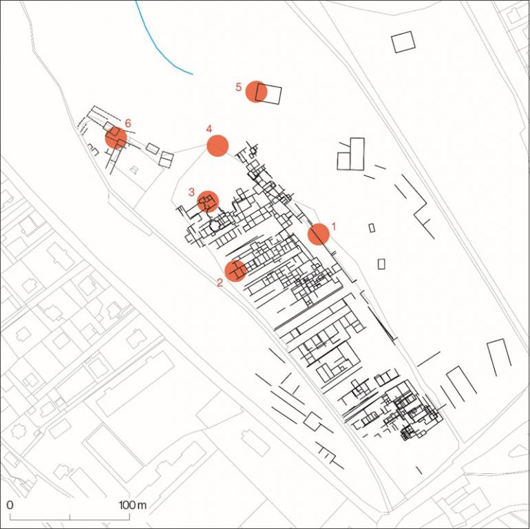
Figure 2: Panorama in Ptuj. The walls of the Roman town on the basis of georadar investigations (Horvat, Dolenc Vičič, Mušič 2018). The areas of the proposed field research are indicated: 1 - presumed defence walls, 2 - the oldest construction phase and the commercial building/artisan workshops, 3 - baths or domus, 4 - the early Christian church, 5 - presumed end of the aqueduct, 6 - presumed sanctuary.
2. Settlement of Poetovio
The archaeological data of different qualities (random finds, protective excavations, old and modern archaeological research, geophysical surveys) are gathered and evaluated in the areas of Panorama, Vičava, the medieval town, and the Castle Hill. A catalogue of the sites is upgraded by a study on the development of the Roman settlement on the left bank of the River Drava and a reconsideration of the entire Poetovio.
3. The Role of Poetovio in the Urban Network
Poetovio stands out from among the surrounding towns by its size, urban structure, economic power, and imperial administration offices. The urban layout and architecture of Poetovio is confronted with remains in other towns in the central Danube region, with particular interest in large towns with special supraregional functions.
PROJECT TEAM
Jana Horvat, Project Leader
Andreja Dolenc Vičič
Marjeta Šašel Kos
Anja Ragolič
Zvezdana Modrijan
Borut Toškan
Tjaša Tolar
Branko Mušič, external collaborator for the geophysical surveys
First year:
Objective 1 - Panorama: geophysical survey of the lower part of the Panorama Hill; trenches in the selected areas.
Objective 2 - Settlement of Poetovio: a corpus of archaeological sites on the left bank of the Drava River in Poetovio.
Second year:
Objective 1 - Panorama: geophysical surveys of the upper part of the Panorama Hill; trenches in the selected areas.
Objective 2 - Settlement of Poetovio: a study of settlement on the left bank of the River Drava.
Objective 3 - The Role of Poetovio: a study on the role of Poetovio in the network of towns.
Third year:
Objective 1 - Panorama: interpretation of the geophysical survey results; detailed analysis of field data and small finds; studies on the chronology, phases and building techniques.
Objective 2 - Settlement of Poetovio: a study of settlement on the left bank of the River Drava (continuation and conclusion).
Objective 3 - The Role of Poetovio: a study on the role of Poetovio in the network of towns (continuation and conclusion).
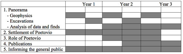
Figure 3: Timetable
HORVAT, Jana, MUŠIČ, Branko, DOLENC VIČIČ, Andreja, RAGOLIČ, Anja, Arheološka najdišča Ptuja. Panorama / Archaeological sites of Ptuj. Panorama. − Opera Instituti Archaeologici Sloveniae 41, 2020.
HORVAT, Jana, NESTOROVIĆ, Aleksandra, Osrčje Petovione: Ptuj v rimski dobi, katalog. 2020.
Exhibition
NESTOROVIĆ, Aleksandra, HORVAT, Jana. Osrčje Petovione : Ptuj v rimski dobi: odprtje razstave, razstavišče na ptujskem gradu [Ptuj in the time of the Roman Empire], Ptuj (SLO), 22. nov. 2019. [COBISS.SI-ID 14016003]