Identifying quarries in the Roman Pannonia
Principal Investigator at ZRC SAZU
-
Original Title
Identifikacija kamnolomov v rimski Panoniji
-
Acronym
GENNI
Project Team
Benjamin Štular, Phd, Assoc. Prof., Mateja Belak, Tilen Podobnik, Snežana Tecco Hvala, PhD, Jana Horvat, PhD, Tina Berden, PhD-
ARIS Project ID
J6-4609
-
Duration
1 October 2022–30 September 2025 -
Link to SICRIS
20090 -
Project Leader
-
Financial Source
Javna agencija za raziskovalno dejavnost Republike Slovenije

This project is intended to provide insight into local quarries, which represent the predominant form and organisation of Roman quarries throughout the Roman Empire. This organisational form provides insight into the dynamics of the quarry industry in the Roman period (1st-4th century AD) and offers a unique perspective on the economic relationships between Roman cities and their immediate surroundings. Identifying the workings of the network of local quarries and establishing links to stone monuments would allow the uncovering of local and regional patterns of production and trade, which is of great value for understanding the Roman economy, especially at the regional and interregional levels. However, despite significant improvements in the methods used in arheometric provenance studies (especially for white marble), it is not easy to establish a link between stone monuments (artefacts) and a specific source (quarry). The overview of the scientific background shows that there are two major problems that need to be addressed in order to establish a more accurate link between quarries and their products. First, a more efficient method is needed to locate and document ancient quarries. Knowledge of the site and the availability of its diagnostic signature for comparison is a critical requirement for matching artefacts to a possible quarry. The second problem is the lack of a scientific infrastructure that would allow an immediate overview of the results of geological analyses conducted on monuments and identified quarries in one place. The same problems occur in provenance studies of stone monuments from the area of the former Roman province of Pannonia.
The goals of the project are
1 − to develop a methodological approach for locating potential ancient quarries and
2 − to provide a scientific infrastructure in the form of a geodatabase that can contain in one place the locations of ancient quarries and their diagnostic data for each site.
The geodatabase would also allow us to retrieve the artefacts that can be associated with a particular quarry. This link could lead to a more detailed picture of the distribution of stones from specific quarries throughout the study region. The project is therefore based on two interconnected parts:
1 − use of LiDAR data and spatial analysis to locate potential quarries and
2 − lithological analysis based on macro- and microlithological descriptions of the stone monuments and rock surfaces identified in the quarries.
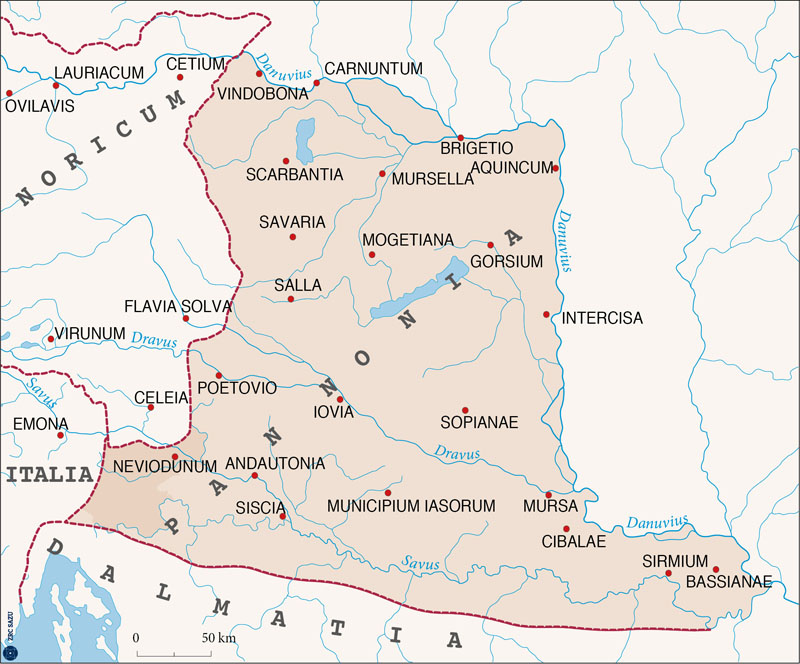
Roman province of Pannonia. The darker part is the field of research.
For the development of the method we have chosen the area of today's Lower and White Carniola (Slovenia). Typical for this selected study area is that it is dominated by small Roman settlements, spatially remote and isolated from the main traffic routes. The numerous stone monuments in their surroundings indicate the use of limestone and the need to open quarries. We therefore believe that it is possible to identify here an organizational model for stone quarrying associated with smaller settlements that can be applied to a larger part of the territory of the Roman province of Pannonia.
Project team
- Assist. prof. dr. Edisa LOZIĆ (project leader, early-stage researcher; female) is GIS and airborne LiDAR specialist working in landscape archaeology. She is uniquely qualified to lead this project with her dual specialisation in Roman stone monuments and archaeological Lidar. Her organisational competences and leadership are demonstrated by leading work packages in international project (FWF Austrian Science Found grant number I 3992), in ERC Pilot project (N6-0132), acting as partner project manager on the awarded CLAUSTRA INTERREG project, and by co-organizing scientific conferences.
- Assoc. prof. dr. Benjamin ŠTULAR (experienced researcher; male; all WPs) GIS and airborne LiDAR specialist, landscape archaeology, and project manager.
- Mateja BELAK (senior research assistant; female; WP 2.1) a database and scientific dissemination (including web design) expert.
- Tilen PODOBNIK (research assistant; male; WP 2.3), expert in LiDAR topography (i.e., LiDAR guided archaeological survey) and archaeological excavation.
- Dr. Snežana TECCO-HVALA (experienced researcher; female; WP 3 consultant), specialist in prehistoric archaeology and prehistoric landscape archaeology with experience in archaeological LiDAR.
- Assoc. prof. dr. Jana HORVAT (experienced researcher; female; WP 3 consultant), consultant, a specialist in Roman period archaeology and landscape archaeology with experience in archaeological LiDAR.
The principal method of this project is first to identify potential Roman quarry zones using airborne LiDAR data. Then, from each potential site, geological samples will be sourced and analysed. The results of this analysis will be compared to the analysis of Roman stone monuments. Each match will provide definite proof that a Roman quarry zone has been discovered. The key innovation in this approach is the first part (WP.1; WP.2) but also in the second part (WP.3) we are using beyond-the-state-of-the-art methods. In addition to the conventional dissemination (scientific publications), the results will be made available in an open-access tool Geo-databank that will allow for provenance identification of analysed monuments to all interested researchers in the future (WP.4).
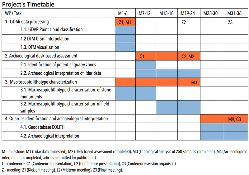
The project is divided into four work packages (WP), and the details of the methodology for each step are further explained below (see Project's Timetable).
- WP.1. Lidar data processing
Tasks: 1.1. LiDAR Point cloud classification; 1.2. DTM 0.5m interpolation; 1.3. DTM visualisation - WP.2. Archaeological desk-based assessment (DBA)
Tasks: 2.1. Identification of potential quarry zones; Archaeological interpretation of lidar data - WP.3. Macroscopic lithotype characterization
Tasks: 3.1. Macroscopic lithotype characterization of stone monuments; 3.2. Macroscopic lithotype characterization of field samples. - WP.4 Quarries identification and archaeological interpretation
Tasks: 4.1. Geodatabase EOLITH; 4.2. Archaeological interpretation
- LOZIĆ, Edisa 2026, Geospatial and Lithological Data on Roman Stone Monuments from Southeastern Slovenia. − Journal of Open Archaeology Data 14/9, 1−5. doi: https://doi.org/10.5334/JOAD.208
- LOZIĆ, E. 2025, EOLITH Database. https://hdl.handle.net/20.500.12102/genii-flex-catalogue
- RIŽNAR, Igor. Identifying quarries in the Roman Pannonia : geological report. Geneva: Zenodo, 2025. 1 oneline source (2 files PDF (42 pp.)). DOI: 10.5281/zenodo.17352813[COBISS.SI-ID 254475267]; category: SU (S)
- LOZIĆ, E. 2025, GENII project (J6-4609) : revolutionizing Roman stoneresearch through EOLITH database integration. Conference contribution. − ASMOSIA XIV: 14th International Conference of the Association for the Study of Marble and Other Stones in Antiquity, 15−20 September 2025, Ljubljana, book of abstracts. (p. 73) [COBISS-ID: 253949443].
- Lozić, E. (2025). Dataset for GENNI project PROJECT (J6-4609) (1.0) [Data set]. Zenodo https://doi.org/10.5281/zenodo.17289465 [COBISS-ID: 253951491].
- LOZIĆ Edisa, ŠTULAR Benjamin, Archaeological LiDAR in Mediterranean Karst Landscapes. A Multiproxy Dating Method for Archaeological Landscape and a Case Study From Prehistoric Kras Plateau (Slovenia). − Archaeological Prospection, 2024, Online Version of Record before inclusion in an issue, 1−19. DOI: https://doi.org/10.1002/arp.1954
- ŠTULAR, B., LOZIĆ E., EICHERT S. 2023, Interpolation of airborne LiDAR data for archaeology, Journal of Archaeological Science: Reports 48, p.p. 103840. https://doi.org/10.1016/j.jasrep.2023.103840