Settlement of the south-eastern Alpine region in the Early Middle Ages
Principal Investigator at ZRC SAZU
dr. Benjamin Štular-
Original Title
Poselitev jugovzhodnoalpske regije v zgodnjem srednjem veku
Project Team
Prof Andrej Pleterski, PhD, Zvezdana Modrijan, PhD, Jernej Rihter, PhD, Mateja Belak, , dr. Andrej Magdič, prof. dr. Manfred Lehner, dr. Edisa Lozić, dr. Iris Koch, dr. Stephan Karl, dr. Christoph Gutjahr-
ARIS Project ID
J6-9450
-
Duration
1 November 2018–31 October 2022 -
Link to SICRIS
17437 -
Lead Partner
-
Project Leader
-
Financial Source


Partners
Zavod za varstvo kulturne deiščine Slovenije, Karl-Franzens-Universität Graz, Institut für Archäologie
Early medieval archaeology (c. 6th-11th centuries ) in the southeastern Alpine region has traditionally focused on the study of burial sites, treasure finds and settlements. In our project we add to these sources the analysis of the economic hinterland and thus the treatment of the landscape as an artefact.

Early medieval sites in the south-eastern Alpine area: red – settlement; grey – other; blue – micro-regions (W to E) Bled, Leibnitzer feld, Dravsko-Ptujsko polje
The aim of the project is a synthetic study of the settlement of the southeastern Alpine region in the early Middle Ages (6th-11th centuries). This is possible through a chronological and spatial analysis of settlement phases for the whole region and through three microregional studies. The latter address selected questions concerning economy, society and culture. Drawing on the tradition of cemetery archaeology (Gräberfeldarchäologie), the project draws on the archaeology of settlements discovered in the last two decades and on modern archaeological methods, including digital tools.

Selected micro-regions
The project leads to the first comprehensive study of the early mediaeval settlement of the southeastern Alpine region, which crosses the borders of modern countries.
Airborne LiDAR data processing
WP 1. ZBIVA web application
Duration: M1 – M3
Leader: Belak (P1)
Participants: All
Tasks
1.1. Training
1.2. Grey literature analysis
1.3. ZBIVA maintenance
Description
The feasibility of entire project is based foremost on the data already collected in ZBIVA, i.e. data on 3368 sites; within WP1 this data will be supplemented with grey literature (e.g. unpublished excavation reports, professional publications).
ZBIVA database, actively developed since 1987, has been designed to compile archaeological scientific data (published in peer-reviewed journals and books) on South-eastern Alpine and surrounding area in the Early Middle Ages. It is focused on the sites in Slovenia, Austria, on the NW Croatian coast, and in the NE regions in Italy. Since 2016 it is available as a full-blown GIS web application. Focusing on peer-reviewed publications gradually became a limitation since in the past two decades ever-larger portion of archaeological excavations is published exclusively as grey literature (e.g. unpublished excavation reports, non-scientific books).
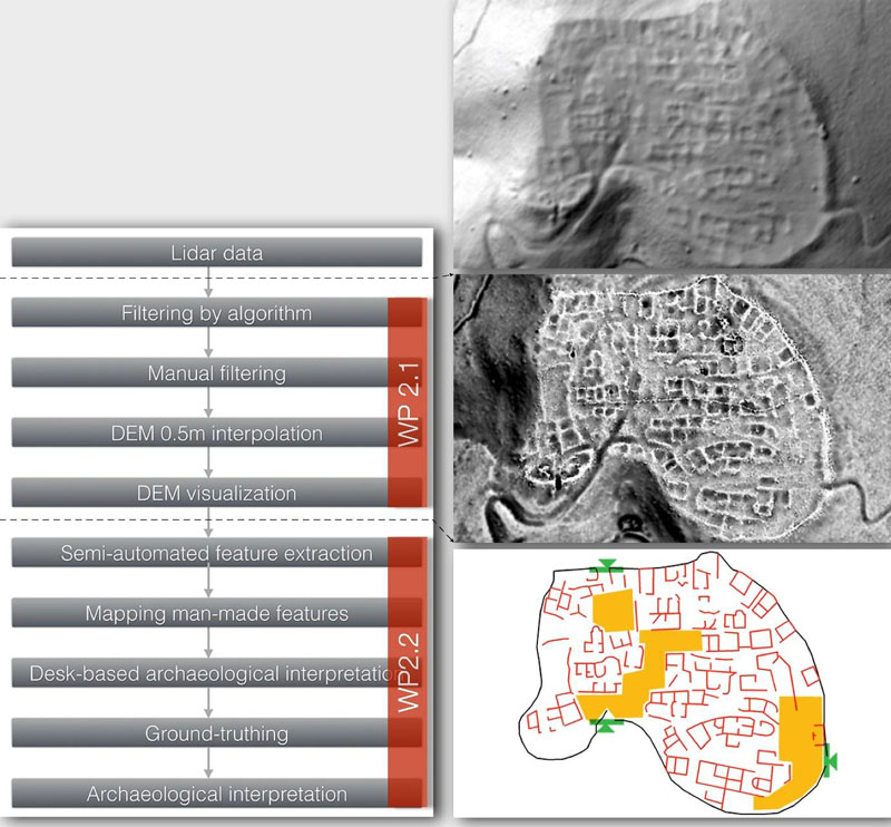
WP 2. Airborne LiDAR data interpretation
Duration: M1 – M30
Leader: Lozić (P3)
Participants: All
Tasks
2.1. Data analysis
2.2. Ground truthing and archaeological interpretation
Description
Airborne Light Detecting and Ranging (LiDAR), also known as airborne laser scanning (ALS) data (henceforth LiDAR), is being used in archaeology for just over a decade. Typically, LiDAR data at least doubles the amount of archaeological information in forested areas and new archaeological information has been extracted in every single reported example. In this project archaeological interpretation of LiDAR data will be primarily used as an aid to contextualize archaeological data in their physical environment, i.e. to convey a new perspective of the physical landscape.
Until recently only small areas (e.g. 15 km2) have been the focus of research and only a limited number of archaeologists have had the skills, software and hardware to harness the full data potential. However, since 2015 Slovenia and Austria offer LiDAR datasets for entire countries that are free or low cost respectively. LiDAR data therefore has a huge potential for creating new archaeological data in south-eastern Alpine region. But this potential is "locked" until the data is appropriately processed and interpreted (Fig. 2).
Therefore, in this project a specialist in LiDAR applications in archaeology will be employed and equipped. The work will be closely coordinated with other project members in all stages from case-study area selection to the final archaeological interpretation. According to the research nature of this project the focus is on in-depth analysis rather than on covering the largest possible area, i.e. less effort is devoted to to data analysis (WP2.1) and more to interpretation and ground-truthing (WP2.2). Nevertheless, minimum 50 km2 will be analysed in each micro-region and minimum 200 km2 in total.
WP 3. South-eastern Alpine region analysis
Duration: M13 – M30
Leader: Štular (P1)
Participants: Koch (P3), Gutjahr (P3), Magdič (P2), Modrijan (P1), Rihter (P1), Pleterski (P1), Karl (P3)
Tasks
3.1. Settlement pattern analysis
3.2. Advanced landscape analysis
3.3. Synthesis, Interpretation
Description
The objectives of WP3 are to detect spatial and chronological processes, in particular (1) areas of the earliest settlement and (2) settlement pattern shifts thereafter. Analysis will source the data compiled in WP1. ZBIVA web application acts both as a database and as an analysis tool. In addition, advanced analyses will be conducted in GIS (geographic information systems). Results will be compiled in a scientific synthesis and interpreted.
WP 4. Micro-regional analyses
Duration: M7 – M30
Leader: Lehner (P3)
Participants: Karl (P3), Gutjahr (P3), Magdič (P2), Modrijan (P1), Rihter (P1), Štular (P1), Pleterski (P1), Koch (P3), Lozić (P3).
Tasks
4. Micro-regional analysis 4.1. Bled (SI) 4.2. Leibnitzer feld (A) 4.3. Dravsko-ptujsko polje (SI)
Description
Micro-regional analysis' by definition studies the smallest possible area that includes all relevant site-types, e.g. central settlement with all depending peripheral settlements, cemeteries, hoards. One can say that a micro-region is to the archaeology what a laboratory is to natural sciences: a place where hypothesys is built, developed and tested.
In this project the focus within each micro-region will be on settlements with their respective site-catchment or hinterland areas (ger. Einzugsgebietanalyse), e.g. field systems, path networks and landscape but also cemeteries and hoards. This is made possible by the use of LiDAR data (WP2), retrograde land-cadastre analysis (ger. Genetische Flurformenforschung) and GIS tools will be employed as appropriate. Each of the three micro-regions was selected for a particular reason relevant to the entire region:
WP 5. Synthesis and interpretation
Duration: M30 – M36
Leaders: Pleterski (P1), Lehner (P2)
Participants: All
Tasks
he objective is the scientific synthesis "Settlement of the Southeastern Alpine Area in the Early Middle Ages" based on the results on all other WPs and in particular WP3 and WP4. One can understand the results of WP3 and WP4 as chapters in the final monograph publication whereas WP5 is the conclusive chapter of the book.
It is the objective of this WP to arrive at meaningful scientific interpretation with combined effort of all researchers involved in the project.
Monograph
Benjamin ŠTULAR (ur. / ed.), Srednjeveški Blejski otok v arheoloških virih / Medieval archaeology of Bled Island. − Opera Instituti Archaeologici Sloveniae 42, 2020.
Articles
- ŠTULAR, B., LOZIĆ, E., BELAK, M., RIHTER, J., KOCH, I., MODRIJAN, Z., MAGDIČ, A., KARL, S., LEHNER, M., GUTJAHR, Ch., Migration of Alpine Slavs and machine learning: Space-time pattern mining of an archaeological data set, Plos One, September 2022, https://doi.org/10.1371/journal.pone.0274687
- ŠTULAR, B., BELAK, M., Deep Data Example: Zbiva, Early Medieval Data Set for the Eastern Alps. – Research Data Journal for the Humanities and Social Sciences, September 2022; https://doi.org/10.1163/24523666-bja10024.
- LOZIĆ Edisa, Application of Airborne LiDAR Data to the Archaeology of Agrarian Land Use. The Case Study of the Early Medieval Microregion of Bled (Slovenia). − Remote Sens. 2021, 13, 3228. https://doi.org/10.3390/rs13163228.
- ŠTULAR, B., E. LOZIĆ 2020, Comparison of Filters for Archaeology-Specific Ground Extraction from Airborne LiDAR Point Clouds. – Remote Sensing 2020 (12), DOI: 10.3390/rs12183025.
- ŠTULAR, Benjamin, EICHERT, Stefan. Hilltop sites with Early Medieval military finds in the Eastern Alpine area : reverse engineering of predictive modelling. − In: Diesenberger, Max, Eichert, Stefan, Winckler, Katharina (eds.). Der Ostalpenraum im Frühmittelalter - Herrschaftsstrukturen, Raumorganisation und archäologisch-historischer Vergleich. Wien: Verlag der österreichischen Akademie der Wissenschaften, 2020, 213−230, 459−478.
- Benjamin ŠTULAR, One phenomena or many? Considerations on the role of selected sites in Slovenia: Na Bleku, Mali grad, and Gradišče above Bašelj. − Winckler, Diesenberger, Eichert (eds.), Der Ostalpenraum im Frühmittelalter – Herrschaftsstrukturen, Raumorganisation und archäologisch-historischer Vergleich. Forschungen Zur Geschichte des Mittelalters 23, 2019, 215−251.
- Edisa LOZIĆ, Manfred LEHNER, Benjamin ŠTULAR, Poselitev jugovzhodnoalpske regije v zgodnjem srednjem veku. − Arheologija v letu 2018, dediščina za javnost, Ljubljana, 2019, 34.
- Benjamin ŠTULAR, Andrej PLETERSKI, Prolog. Zgodnjesrednjeveška arheologija jugovzhodnoalpskega prostora: nekoč, danes, jutri / Prologue. Early Medieval archaeology in the South eastern Alpine area: past, present, future. − Judita Lux, Benjamin Štular, Katharina Zanier (eds.), Slovani, naša dediščina / Our Heritage: The Slavs, Vestnik 27, 2018, 8−15.