Methodological Maturity of Airborne LiDAR in Archaeology - Pilot Project (MALiAp)
-
Original Title
Metodološka zrelost zračnega laserskega skeniranja v arheologiji - pilotni projekt (MALiAp)
-
Acronym
MALiA
Project Team
Edisa Lozić, PhD, Asst. prof., , doc. dr. Žiga Kokalj, Mateja Belak, Tilen Podobnik-
ARIS Project ID
N6-0132
-
Duration
1 October 2019–30 September 2022 -
Link to SICRIS
17934 -
Project Leader
-
Financial Source

The use of airborne LiDAR in archaeology has produced an unprecedented amount of new data in the last few years. Airborne LiDAR is the only remote sensing technique that enables detecting surface with high precision even in the forests. This data enables archaeological interpretation of often minuscule surface anomalies that are revealing of e.g. buried settlements or entire arcchaeological landscapes and ancient pathways. But the benefits for archaeology as a discipline remain limited. To remedy this, airborne LiDAR must evolve from a specialist discipline within archaeology into a background topic of all archaeology. The start of this process is timely since the external obstacles – foremost unavailability of free or cheap data – have been overcome recently. However, three key bottlenecks internal to archaeology have been identified:
(i) the lack of integrated research,
(ii) the lack of suitable publications, and
(iii) insufficient understanding of the method on the part of non-specialists.
The original ERC-CoG project proposal MALiA aimed to directly address these issues by
(i) implementing three integrated research case studies,
(ii) launching a publishing platform that will enable and encourage timely dissemination of aLiDAR-derived archaeological interpretation and
(iii) setting up a network for training non-specialists in integrating aLiDAR-derived archaeological interpretation into research.
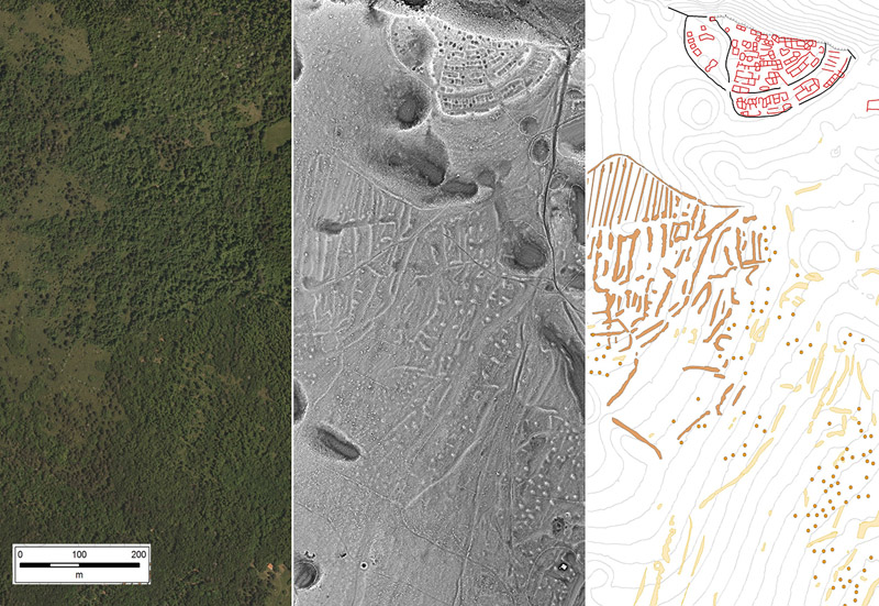
Knežak, Notranjska
The aim of this modified project MALiAp is to be a pilot project by implementing a selected task that will lead towards achieving the goals of the original project proposal. Specifically, the MALiAp's goal is to (i) implement one integrated research case study. This particular goal has been selected for two reasons.
Firstly, it can be implemented independently of other activities proposed in the original project without any negative effects on the research quality.
Secondly, it will demonstrate the ability to conduct ground-breaking research which will eliminate the main deficit highlighted by reviewers of the original proposal.
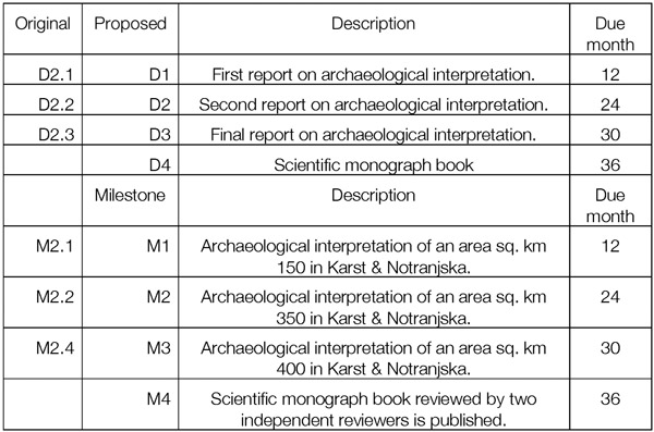
These case study selected will be based on the archaeological interpretation of 400 sq. km of airborne LiDAR data in the Notranjska and Karst regions. The true potential of this data is currently hindered by the sheer quantity: based on sample areas there is estimated 125,000 archaeological features in the entire Notranjska and Karst regions. This potential will be unlocked for archaeology by the MALiAp project.
Research Team
- Benjamin Štular; team leader
- Žiga Kokalj; technical support for archaeological interpretation of aerial laser scanning data, technical support for the production of the final publication
- Edisa Lozić; technical support for archaeological interpretation of aerial laser scanning data, technical support for the production of the final publication
- Mateja Belak; data support for archaeological interpretation of lidar data (ARKAS, analysis of scientific and expert literature), technical support for the production of the final publication, design and maintenance of the project website
- Tilen Podobnik; archeological field survey in support of archaeological interpretation of lidar data
Journal
We are co-editing a Special Issue in the peer-review and open-access journal "Remote Sensing" (ISSN 2072-4292; https://www.mdpi.com/journal/remotesensing; IF 4.509) titled Geocomputation Using Remote Sensing Data for Landscape Archaeology.
Visualisation for archaeological topography (VAT General) of Slovenia's lidar data:
https://gisportal.gov.si/arcgis/rest/services/TEMELJNE_KARTE/LidarTlaZgradbe_D96/MapServer
Online Map Viewer:
https://www.arcgis.com/home/webmap/viewer.html?basemapUrl=https%3A%2F%2Fgisportal.gov.si%2Farcgis%2Frest%2Fservices%2FTEMELJNE_KARTE%2FLidarTlaZgradbe_D96%2FMapServer&source=sd
![]()
Open Open LiDAR Toolbox
is a QGIS plug-in for one-step-processing of airborne LiDAR data from point cloud to LiDAR visualisations. The required input is an unclassified point cloud in LAZ/LAS format and the tool returns outputs needed for interpretative mapping of archaeological features. In addition, several other tools are available for multi-step data processing. The tools are optimised for archaeology, but have a broader application for anyone primarily interested in visual inspection of airborne LiDAR, e.g., topographic mapping. List of tools: * 0NE (One-step- processing); * Classify LAS/LAZ; * Create base data; * DFM confidence map; * Hybrid interpolation; * Visualisations (from DFM).
Link: https://stefaneichert.github.io/OpenLidarToolbox/
***
We are co-organisers of the international scientific conference and workshop TRAIL 2022, the largest single event in the field of archaeological LiDAR in the world.
***
- LOZIĆ Edisa, ŠTULAR Benjamin, Archaeological LiDAR in Mediterranean Karst Landscapes. A Multiproxy Dating Method for Archaeological Landscape and a Case Study From Prehistoric Kras Plateau (Slovenia). − Archaeological Prospection, 2024, Online Version of Record before inclusion in an issue, 1−19. DOI: https://doi.org/10.1002/arp.1954
- ŠTULAR, B., LOZIĆ E., EICHERT S. 2023, Interpolation of airborne LiDAR data for archaeology, Journal of Archaeological Science: Reports 48, p.p. 103840. https://doi.org/10.1016/j.jasrep.2023.103840
- ŠTULAR, Benjamin, LOZIĆ Edisa, Airborne LiDAR data in landscape archaeology. An introduction for non-archaeologists. – Journal it - Information Technology, july 2022.
- ŠTULAR, B., EICHERT S, LOZIĆ E., Airborne LiDAR Point Cloud Processing for Archaeology. Pipeline and QGIS Toolbox, Remote Sensing 13, no. 16: 3225. https://doi.org/10.3390/rs13163225
- ŠTULAR B., LOZIĆ E., EICHERT S., Airborne LiDAR-Derived Digital Elevation Model for Archaeology, Remote Sens. 2021, 13(9), 1855; https://doi.org/10.3390/rs13091855.
- LOZIĆ, E., ŠTULAR, B. 2021, Documentation of Archaeology-Specific Workflow for Airborne LiDAR Data Processing, Geosciences 2021, 11(1), 26; https://doi.org/10.3390/geosciences11010026
- ŠTULAR, B., E. LOZIĆ 2020, Comparison of Filters for Archaeology-Specific Ground Extraction from Airborne LiDAR Point Clouds. – Remote Sensing 2020 (12), DOI: 10.3390/rs12183025.