Digital Archaeology of a Slovenian Hillfort Landscape
Principal Investigator at ZRC SAZU
-
Original Title
Digital Archaeology of a Slovenian Hillfort Landscape
Project Team
Edisa Lozić, PhD, Asst. prof., , Adrienne Frie, PhD, Jernej Rihter, PhD, , Boštjan Laharnar, PhD, , Dr. Boštjan Laharnar-
ARIS Project ID
BI-US/22-24-126
-
Duration
1 July 2022–30 June 2024 -
Lead Partner
-
Project Leader
-
Financial Source
Javna agencija za raziskovalno dejavnost Republike Slovenije

Description
In late prehistory, hillfort settlements surrounded the Razdrto Pass and were placed along the ridge of Taborski Greben to the south stretching over 50 kilometers. These settlements were a threat to the Roman colony of Aquileia (founded 183/181 BCE) and successive incursions by the Romans moving east sought to control this strategically essential area. Historic records of Roman incursions in this area include the plundering campaign by Gaius Cassius Longus in 171 BCE, campaigns by Gaius Sempronius Tuditanus in 129 BCE, Lucus Aurelius Cotta and Lucius Metullus in 119 BCE, Marcus Aemilius Scaurus in 115 BCE, Julius Caesar during his proconsulship between 59 and 49 BCE, and Octavian’s Illyrian Wars between 35 to 33 BCE. The available evidence indicates a distinct north-south split between hillforts in the area of the Razdrto Pass and the Taborski Greben. Settlements in the north surrounding the pass were destroyed in the second and first centuries BCE and in certain cases reoccupied by the Roman military. Those along the ridge of Taborski Greben in turn survived the period of conquest and subsequent archaeological remains include both Roman and autochthonous material culture, possibly indicating cohabitation of Roman and autochthonous populations until the Late Roman period (5th century CE).
The proposed project will investigate this transformative period with the following research objectives:
1. To understand changing landscape use related to cultural identity from the Iron Age into the Roman period, particularly in the context of violent military engagements between populations.
2. To understand the dynamics of settlements and their hinterlands, and how those connections were manifested in anthropogenic landscape features.
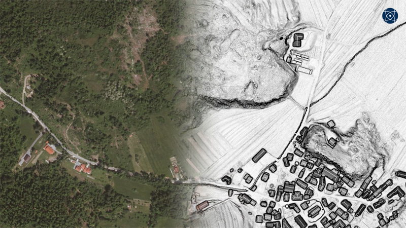
The research team employs a multi-scalar, mixed-method approach to address these questions, including excavation, creation of microregional LiDAR landscape data, interpretive mapping of these processed data, and ground assessment of LiDAR-derived information. On the regional level, ground assessment of the area of the Razdrto Pass (ancient Ocra Pass) to modern Ilirska Bistrica will provide evidence for understanding the North/Pass vs. South/Ridge landscape use. On the inter-site scale, comparisons of ground-identified features in the area from modern Šembije to Šilentabor provide a more nuanced picture of settlement in the periods before and after the Roman conquest. Additionally, the data collected through directed UAV LiDAR are used to create higher-resolution interpretive maps of the Slavina microregion focused on the four hillforts around Slavina: Baba, Ambroževo gradišče, Gradišče above Selce, and Podvršek. These data allow new perspectives on aggregate hillfort landscapes, which demonstrate different Iron Age histories and post-Roman occupation, despite being within a 5 km2 area. Finally, at the intra-site level, directed excavations at the Baba hillfort in Slavina provide a detailed layout of this late prehistoric settlement, and also reveal the types of strategies employed by Iron Age peoples against the Roman invaders.
Project leader with project partner is Adrienne Frie, PhD.